Hi all,
This is from Laura Miniel, you may have met me during campaigns in the past. I'm usually the data analyst/ data manager / polling person running phonebank or other surveys.
I'm writing to you today as a guest editor because of an important thing on all of our radars, which is Hurricane Beryl.
I've long been fascinated by numbers and relationships between measurements. I used to participate in a gambling "game", a paid exercise where you could put bets in dollar amounts on where you thought a projected hurricane would land. This was through weather.com or some similar website. Anyway, they would pay you if your prediction was correct, and you would lose your bet if you were wrong. I think the prediction had to be within 25 miles of the actual eyewall landing site. It no longer exists, but I used to play this game a lot during the time it did, and was able to refine my own predictions and become pretty good at it.
The most predictive factor I found, the one that tended to result in a lot of unexpected wins was using the NOAA (National Oceanographic and Atmospheric Administration) heat index report. This is a model of expected heat index values for different places a few days into the future. What I found is the highest heat indexes tended to predict where the hurricanes would land. This is because when you think about air molecules and water molecules, think about a crowd of people. Let's say you are a person walking into a nightclub, and you're moving forward trying to get to the back wall of a room to an exit door. Let's say you've got two main groups of other people in the room. One group is dancing and moving around with a lot of energy, and the other group surrounding them is stuck together like a wall of people shoulder to shoulder arms locked. Where would your path go to get from your starting point and through the room?
Well, it would be easier to go through the gaps of moving, sparsely-separated dancing people than through a solid wall of people standing clustered together right? Particularly if the dancing people are already in motion and moving toward the back of the room. And I think physically this is what is happening with the air molecules. It's just known that objects in motion tend to stay in motion and it's easier to push through something airy, warm and already in motion than something hard, cold and solid. The heat index itself includes humidity and this is important also.
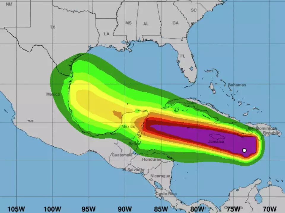
I'm writing this, and I hope not to be an alarmist, but because I pulled the NOAA heat index projection for Monday and this is what it looks like. The RGV is starkly the target.
This is extremely upsetting to me because, looking at this, Brownsville is where I'd place my bets for the eyewall to land, or close nearby. One weakness of this graph is that we don't have any reporting from Mexico and there may be places with even higher intensity heat/humidity there that could be a bigger draw.
The recent tropical storm hardly touched Brownsville, and so we didn't get the cooling effect that could bring the air molecules together and ward this off. Probably why you see this purple triangle on NOAA's map. Most professional predictions seem to focus on air pressures, but I am specifically talking about heat index values here. The valley and Mexico around us got hit by Alberto worse, to the point Brownsville folks seemed kind of dismissive about how weather forecasts are overblown and exaggerated and Brownsville got nothing to worry about. Other places nearby got cooled off, their air molecules condensed, but Brownsville solely remains the hottest/wettest area, making us the biggest draw physically for a new storm system if the heat index truly is predictive of track.
Another negative factor is the extreme heat caused by climate change in general, has warmed up the ocean in the Gulf to where I personally am not confident that Beryl is going to slow as much after crossing Jamaica and Mexico. Though I hope desperately it does.
I hope to God I am wrong about this. I would relish that 10000x more than being right and seeing the destruction I am afraid of seeing take place here in my home, in Brownsville. I was a HEB today and everyone seemed to be shopping like normal for the 4th of July, and that was kind of freaky, like don't you realize what could be coming here?
I'm writing to Jim Barton to (hopefully not without merit) to share this warning. That our close shave with Alberto isn't something you should base your expectations for Beryl on, but see it as a missed opportunity for much-needed rain and cooling in this area. The fact we alone missed most of the rain could be drawing the next storm system directly to us to finish the job. Homeostasis operates in biological systems such as individual humans, animals and plants --and also planet-wide.So I am stepping out, even as the most amateur of amateur weather predictors, and as someone with zero (let me repeat, zero!!) training in weather or climate prediction, but just as a person who loves deep-diving into data and my own experience betting on storm paths in the past. And there is still plenty of time for the hurricane path to change, and this is very early and it may well do so, and I truly hope so.
Laura A. Miniel


.png)
Brownsville residents are getting ready. People went to get sand bags and if more sand bags are offered, people will go and get more.
ReplyDeletePeople bought water, batteries etc Most people in Brownsville have flashlights, candles Few have generators. People are going to the stores to buy the necessary items but are not into panic shopping....we know we are going to face a flood, we know we are going to get hit by trees, we know the water will go into our house and there will be no electricity and no internet and no exit from our neighborhood. Elderly people, single mothers, children, pets: we are strong, in our poverty. God will protect us.
Settle down, John Brown. We'll get some tailwinds from a tropical storm, the lawns and plants will get a good soaking, a fence or tree will fall down, we'll cool off for a couple of days, four corners will flood, then we'll all go back to our mundane existence indoors to escape the thick heat. Ten to one the eye doesn't go over Cameron county.
ReplyDelete